
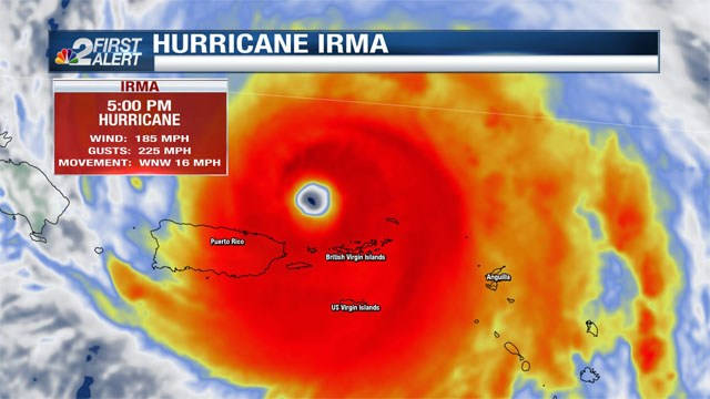
Irma holding with 185 mph sustained winds


That’s according to the most recent advisory as of 8 p.m. tonight from the National Hurricane Center.
Over the past day, Hurricane Irma has moved over several islands between the Caribbean and Atlantic including parts of the British Virgin Islands, Barbuda, St. Barts, and St. Martin. Based on news coming out of this area of the world, at least 2 people have died as a result of the hurricane.
The biggest development in the past 24 hours when it comes to the forecasting of this hurricane is a subtle trend toward the east in the projected path when it nears Florida. This is something new in the forecast models on Tuesday, and reflected in the latest forecast cone from the National Hurricane Center.
Despite the modest eastward trend in the forecast data, all of Southwest Florida remains in the cone this weekend, specifically on Sunday
In terms of what our area could see, the earliest arrival of tropical storm-force winds will likely be felt by late Saturday. Hurricane force winds could move over the area on Sunday or Monday, depending on the eventual path the hurricane takes.

Projected rainfall is on the order of five inches or more across Southwest Florida by Monday. Rainfall totals will be highly dependent on which side of the state the eye passes on.
The forward movement of Irma this morning is to the west-northwest at 16 mph. In the past few hours, the minimum central pressure has fallen to 920 millibars.
Hurricane-force winds extend up to 50 miles from the center of the storm, and tropical storm-force winds go out up to 175 miles from the storm.
It’s important to remember forecast cones change based on storm movements and incoming data, but as time has gone on, a U.S. landfall appears increasingly likely.
Everyone from the Gulf coast of Florida to the Carolina coast needs to monitor this storm with vigilance.
– Check out our interactive NBC2 Hurricane Tracker

It is important for Southwest Floridians to know that should Irma hit our area, the greatest impacts would not be expected until late in the upcoming weekend toward Sunday.
Water ocean temperatures above 80° and low wind shear (weak to little increase in speed or change in direction with height) are conducive for tropical features like Irma to remain healthy or grow stronger.
The only potential hold-up in the further intensification of this storm is the potential of an eyewall replacement cycle. This is when an outer eyewall replaces the current one, and tends to at least temporarily, weaken the storm to a degree.
There are still a number of scenarios on the table for Irma after we move through the next five days.

Now is the time to just be prepared, not to panic.
Living where we do in the world, your hurricane plan should already be in place. This includes having a stocked hurricane supply kit including items like water, batteries, food, and clothing.
Review proper hurricane kit guidelines, brush up on storm evacuation zones and learn more about how storms form using our online hurricane guide at nbc-2.com.
This week is going to be information overload on Irma, so you want to be sure you’re getting your information from a reliable source. The NBC2 First Alert Hurricane Tracking Team will continue giving you frequent updates online, on the air, and on social media.
You can expect updated forecast cones and advisories from the National Hurricane Center every 6 hours, at 5 a.m., 11 a.m., 5 p.m. and 11 p.m. Intermediate advisories are posted between the full updates offering a status report on how the storm is doing in the meantime.
– Watch and learn from the NBC2 Great Hurricane Challenge Quiz Show
Count on the NBC2 First Alert Hurricane Tracking team for the latest on Irma and track its progress with the NBC2 Weather app.

(C) Towsurfer.com 2017
More From Towsurfer
 WEIRD RUMBLINGS AND XL TUBES AT OREGON’S MOST VOLATILE REEF
 Swell Forecast for Chile and Peru by Chris Owens / May 27, 2017
 3X WORLD CHAMPION MICK FANNING ANNOUNCES HIS RETIREMENT FROM WSL WORLD TOUR
 Jeff Rowley Interview 10-20-12
 BRUCE BROWN, LEGENDARY DIRECTOR OF THE ENDLESS SUMMER, HAS DIED
 PICTURES: HURRICANE IRMA RIPS THROUGH CARIBBEAN