
CATEGORY 5 HURRICANE IRMA THREATENS
CARIBBEAN AND FLORIDA

9-5-17
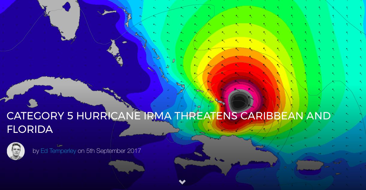
Hurricane Irma has upgraded to an extremely dangerous Category 5 hurricane, with some additional strengthening still possible. You can keep an eye on the storm here.

Drawing a line across the top of the Caribbean, Irma is expected to affect the northeastern Leeward Islands, accompanied by life-threatening wind, storm surge, and rainfall. She is also expected to affect the British and U.S. Virgin Islands, Puerto Rico, the Turks and Caicos, the Bahamas and Cuba.
There is a reasonable chance of seeing severe impacts from Irma in the Florida Peninsula and the Florida Keys later this week with Miami currently forecast to receive a direct hit.

Miami’s South Beach forecast for Sunday, September 10.
See below for the current forecast track from Hurricane Irma.

Why has Hurricane Irma intensified over warmer waters?
The engine of a hurricane is powered by water vapor condensing into liquid and releasing latent heat. We hear this a lot, but what exactly does that mean?
Imagine water vapor bubbling out of the ocean surface which has to be around 26.6 degrees C (80 degrees F) – think of it as a bubbling cauldron expelling rising columns of hot air which are lighter than the surrounding air. Half a mile up, as the air cools, the water vapor condenses back into minuscule liquid water droplets which form vast clouds.
At this point, the water vapor releases the latent heat (which the sun imparted into it earlier) back into the atmosphere and we have a storm. If you were an observer floating above this developing system you would suddenly be able to to see vast towering thunderclouds being created, some rising to 10 miles high as the hurricane’s engine kicks into gear.
UPDATE: Monday, September 4
Irma has taken a turn for the worse, tracking to the south along a strong mid-level ridge over the central Atlantic. She is expected to hit the Leeward islands as a major hurricane, before bumping along the Northern Caribbean on a destructive path through to Florida and beyond. See below for the full official warnings from this extremely dangerous storm.
Additional intensification appears likely with development to Category 4 expected within the next 24 hours.

KEY MESSAGES FROM NHC:
1. Irma is expected to affect the northeastern Leeward Islands as a dangerous major hurricane, accompanied by life-threatening wind, storm surge, and rainfall impacts, along with rough surf and rip currents. Hurricane warnings have been issued for portions of the Leeward Islands. Preparations should be rushed to completion, as tropical-storm force winds are expected to first arrive in the hurricane warning area by late Tuesday.
2. Irma could directly affect the British and U.S. Virgin Islands and Puerto Rico as a dangerous major hurricane later this week. Hurricane watches have been issued for these areas, and tropical storm-force winds could arrive in these areas by early Wednesday.
3. Irma could directly affect Hispaniola, the Turks and Caicos, the Bahamas, and Cuba as a dangerous major hurricane later this week. Residents in these areas should monitor the progress of Irma and listen to advice given by officials.
4. There is an increasing chance of seeing some impacts from Irma in the Florida Peninsula and the Florida Keys later this week and this weekend. In addition, rough surf and dangerous marine conditions will begin to affect the southeastern U.S. coast by later this week.
Otherwise, it is still too early to determine what direct impacts Irma might have the continental United States. However, everyone in hurricane-prone areas should ensure that they have their hurricane plan in place, as we are now near the peak of the season.

Irma’s predicted location for Thursday, September 7.
UPDATE: Saturday, September 2
As expected, Irma has downgraded overnight and the forecast is far from certain during the next few days as the system moves over lukewarm SSTs and encounters dry air. In three to five days the water is set to warm and the atmosphere will contain more moisture which should fuel intensification, however, Irma will also encounter increased wind shear which will limit development. The National Hurricane Centre has altered their forecast guidance accordingly to between Category 2 and 4 by the middle of the week.

Things are more certain in terms of storm’s track with the good model agreement (see image above) of a turn to the west-northwest on Tuesday and skimming the Lesser Antilles. Beyond that, there is the possibility of Irma making some kind of landfall between the Outer Banks and New York if it misses the Bahamas and Florida. The official advice is that too early to determine what direct impacts Irma will have in the Bahamas and the continental United States but for everyone to be prepared.

Right now September 10 doesn’t look like a good day for Long Beach, but a lot can, and will, change.
In terms of surf? Look for locations west of Irma which will get the swell without the consequences. We hear that Kelly Slater is bemoaning his inability to frequent a favored locale.
UPDATE: Friday, September 1
Irma intensified to a Category 3 system on Thursday and is forecast to hit Category 4 status (sustained winds of 130-156 mph or 209-251 km/h) somewhere east of the Leeward Islands early next week. Following a period of rapid intensification, the system is currently moving through a cooler area of ocean, which will limit further development and promote some weakening. Thereafter, Irma is expected to move into a more favorable thermodynamic environment while remaining in low wind shear conditions, which should allow the hurricane to intensify further.
Hurricanes need water above 26°C to gain strength – think of them as an engine driven by heat, one which is potentially incredibly destructive but also fragile. Too much wind shear, not enough moist air, or too much interaction with land and the storm will weaken. And it is this opposite combination of warm water and low wind shear which could fuel further intensification early next week.

So far so good in terms of what we know, however, long range hurricane tracks and intensity are notoriously difficult to predict, and the current scenarios for Irma range from a pass into the Caribbean, through to a king-hit of the Outer Banks or New York. There are two clusters of model agreement in terms of long term direction for this system with the ECMWF and HWRF models calling for southerly track at about 5 days out, whilst the UKMET, GFS, CTC and HMON favoring a move to the north.
We’ll keep an eye on this doubled-edged system which could potentially impact the Caribbean, or provide perfect surf to parts of islands like Barbados before skirting north of the Leeward Islands and hitting mainland USA. For surfers, a best case scenario for Irma would be to emulate Hurricane Bill as a surf producer – if she peels north and hits a high-level easterly flow. Unfortunately this latter scenario, whilst ideal for East Coast surfers and fans of hurricane swells, is currently an edge case.

(C) Towsurfer.com 2017


