
Tropical Storm Bret Named, Is Cindy next in the Gulf?

June 21, 2017
Written by Charlie Hutcherson/Surfline (originally posted here) June is not when we expect to be tracking two tropical features, including Tropical Storm Bret, in the Atlantic. Putting the brief, preseason Tropical Storm Arlene aside, on average it is typically early July before we see our first named cyclone, early August before the second named an nearly mid-August before the third. The early activity is more the norm over the East Pacific, which beats these Atlantic benchmarks by a full month or more.

LOLA wave height forecast in the Gulf of Mexico on Tuesday June 20th shows increasing surf for some, rain and winds for others. Image: Surfline
But here we are, coming out of mid-June, looking at Tropical Storm Bret and a potential ‘Cindy’ in the Gulf of Mexico. While neither feature is forecast to be long lasting, or strengthen much beyond minimal tropical storm strength, they each could have some weather and surf impacts.

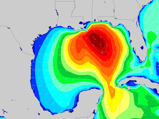
Latest on Potential Tropical Cyclone Three in the Gulf of Mexico. Image: NHC
Here is an outlook on the two features we’ll be monitoring over the coming day. Look for updates in the Surf Feed on the new Surfline or the Surfline app, and check your Regional Forecast on any potential surf at your local break.
— Potential Tropical Cyclone Three in Gulf of Mexico
A disturbance in the Gulf of Mexico, about 300 miles south if the Mississippi River, has shown 35kt winds but no closed center of circulation. Hurricane Hunter aircraft are investigating on Monday afternoon as the disturbance moves northward toward the Louisiana coast at 7kts. Development into a tropical cyclone (Cindy) and some slight strengthening is possible over the next 48hrs as the system approaches the coast. The disturbance is forecast to make landfall in around 72hrs but major models differ on where along the coast this will occur, ranging from southeastern Louisiana to far eastern Texas.

Latest visible satellite image of the Gulf of Mexico and Caribbean Sea. Image: NOAA/SSD
The National Hurricane Center has initiated advisories under Potential Tropical Cyclone Three. A Tropical Storm Warning is in effect from Intercoastal City, LA to the mouth of the Pearl River. A Watch is in effect from Intercoastal City, west to High Island, TX. Heavy rains and local flooding over the central Gulf states are the biggest threats at this time. Look for surf to build over the first half of the week for the eastern and northern Gulf beaches, spreading west for midweek, pending strength and track of the disturbance.

Latest on Tropical Storm Bret heading into the Caribbean Sea. Image: NHC
— Tropical Storm Bret Near Venezuela & Trinidad
Tropical Storm Bret was named on Monday afternoon after Hurricane Hunter aircraft was able to search out a well-defined closed circulation with 35kt winds. Bret is 125 miles southeast of Trinidad off the northern coast of South America, moving quickly west-northwest at 26kts. No significant strengthening is expected as Bret heads into the Caribbean Sea where wind shear and interaction with land is expected to lead to dissipation in the next 72hrs. If Bret heads more westerly into Venezuela, it could dissipate sooner and before reaching the Caribbean Sea.
Tropical Storm Warnings are in effect for Trinidad, Tobago, Grenada, and parts of Venezuela; a Watch is in effect for Bonaire, Curacao, and Aruba. Heavy rainfall is expected over parts of Venezuela and the Windward Islands today and Tuesday. Parts of the Windward Islands, the northern coast of South America and then exposed breaks in the Caribbean Sea could see an increase in windswell over the next few days.

(c) Towsurfer.com 2017
More From Towsurfer
 Surf Legend Kelly Slater Just Bought a $7.8 Million Home on the North Shore
 What is Shane Dorian riding? A very, very diverse quiver
 Towsurfer Model Towboards
 Mike Parsons Interview from the 2002 Towsurfer Vault
 SOOO PITTED! THE GREATEST SURF HOAX OF MAINSTREAM MEDIA!
 (NEW PRODUCT) WU Last Chance Floating Rope For Rescue Sleds